Bike the White Ridge Trail (Moonscape Ride) in San Ysidro
Bike the White Ridge Trail (Moonscape Ride) in San Ysidro
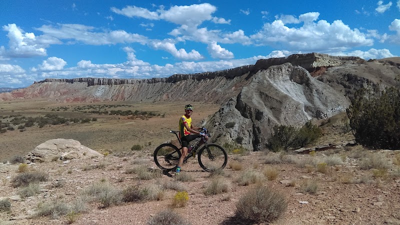
The White Ridge Trail in San Ysidro, New Mexico, offers one of the most visually striking and technically engaging mountain biking experiences in the Southwest. Known as the Moonscape Ride, this trail features surreal terrain composed of stark white gypsum formations, offering an almost extraterrestrial riding experience. Its dramatic ridges, steep descents, and breathtaking views make it a bucket-list destination for mountain bikers craving an adrenaline rush and a unique landscape.
### Adventure Guide to Bike the White Ridge Trail (Moonscape Ride)
Trail Overview
- Location: Near San Ysidro, approximately 50 miles northwest of Albuquerque.
- Distance: ~8.4 miles (loop).
- Difficulty: Intermediate to Advanced—rocky sections, steep climbs, and technical descents.
- Surface: Predominantly gypsum and sandstone, creating a slick, hard-packed surface that can be slippery when wet.
This loop trail takes riders over rolling gypsum hills with challenging inclines and fast-flowing descents. The ridge section offers exceptional panoramic views of the Rio Puerco Valley, with exposed sections that demand skill and confidence.
Key Features and Amenities
- Technical Challenges: Several tough switchbacks, a few short but steep climbs, and technical drop-offs.
- Trail Markings: Well-marked but can be confusing in areas—a GPS track is recommended.
- Nearby Amenities: No facilities—bring plenty of water and supplies. The nearest services are in San Ysidro or Bernalillo.
### Local Insights
- Geological Wonder: The landscape is composed of gypsum, a soft mineral that reflects sunlight, giving the look of an alien world.
- Movie-Ready Scenery: The otherworldly terrain has drawn interest from photographers and filmmakers.
- Historical Context: The terrain was shaped by ancient inland seas, leaving behind rolling hills and exposed ridgelines.
### Visitor Tips
- Best Time to Ride: Spring and fall offer ideal temperatures; summer can be dangerously hot.
- What to Bring:
- Helmet, gloves, and protective gear (due to jagged terrain).
- At least 2L of water per person.
- Spare tube and repair kit (sharp gypsum can cause punctures).
- Directions: From Albuquerque, take US-550 northwest for ~45 miles, turn south onto Cabezon Road, then onto White Ridge Trailhead Road (dirt)—allow 1h 15m travel time.
Reviews
Justin Heynekamp3 years ago
Great trail system and 45 min NW of Albuquerque. Medium skill level mountain bikers and higher will enjoy the area. Amazing landscape and scenery. Dirt road can be rough especially when wet or after rain/snow.
Phillip Ortiz2 years ago
Amazing scenery! I've been here mountain biking 4 times now. I usually go on cooler days (50-85 degrees max!). There is basically no shade, so wouldn't recommend coming here on 90°+ days unless you bring a ton of hydration and snacks. The views are spectacular from the top of "dragons back" and "fun times". I usually do the 8.4 mile recommended loop on the MTB Project app. I notice a lot of people hike and trail run here roo. Some steep parts, if you mountain bike and loose rock but nothing too insane. Theres some really awesome springs further into the trail as well. Phone service minimal at parking lot but works slightly better out on trail. The road leading to the parking lot is very dusty and bumpy with speed grooves so drive slow. Wildlife observed was few bird species and cattle. If you love hiking or mountain biking I highly recommend doing this place AT least once. There is one part in dragons back that is a short lived but STEEP which makes it more ideal to have someone with you because you'll have to carry or pull your bike up. I'm 37 and in decent shape and I was able to drag my bike up by myself, but it also wasn't easy there's loose rock which makes it harder. This part would be easier if your hiking with no bike.
Joshua Thomas2 months ago
This is an awesome place to get in a solid ride. Lots of punchy climbs, nothing too technical. Some narrow sections of trail just don't look down.
Tracy B2 years ago
Beautiful hike! (But I would never ride my mountain bike here. One false move and it's a long way down. 🙃) But the hiking was amazing and so much to explore. Nice trail flow and beautiful views of scenery that changes depending on which direction you take. No shade at all, so best for evening, morning or cooler weather. Very worth navigating the bit of unimproved road to get to the trailhead.
abiracmd3 years ago
Wow what an amazing place to mountain bike and hike. For biking, I would put most of the available trail system here at late intermediate to advanced due to the repercussions of mistake along some of the ridges. The trail itself is not crazy technical. Anyone with a fear of heights would probably not enjoy biking here. All that aside the trail itself is a blast to ride and the views are amazing. Trail system is easy to navigate since there are only a few options. Hiking would be great here as well. Parked at the more northern tail head. No restrooms or water at either TH.