Experience the Diamond Head Summit Trail, Oahu:
Experience the Diamond Head Summit Trail, Oahu:
Introductory Overview
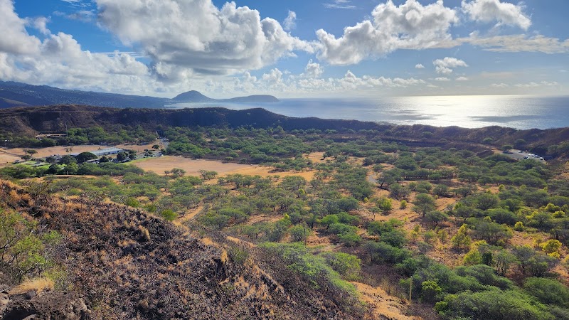
The Diamond Head Summit Trail is one of Oahu’s most famous hikes, offering panoramic views of Honolulu and the Pacific Ocean. Located within the Diamond Head State Monument, this 1.6-mile round-trip trail ascends to the edge of a volcanic crater formed around 300,000 years ago. The steep climb, uneven terrain, and staircases make it a moderate challenge, but the breathtaking scenery and historical significance make it a must-do when visiting Hawaii.
### Adventure Guide To Experience the Diamond Head Summit Trail, Oahu:
The Trail and What to Expect
- The trail begins at the base of Diamond Head Crater, with a gradual incline before transitioning into a series of steeper switchbacks.
- The last section includes 99 steep steps, a short tunnel, and a spiral staircase leading to the summit.
- At the top, hikers are rewarded with one of the most iconic views in Hawaii, overlooking Waikiki, the southeastern coastline, and distant Molokai on clear days.
History of Diamond Head
- The crater, called Lēʻahi in Hawaiian, was named by British sailors who mistook calcite crystals in the rocks for diamonds.
- The trail itself was built in 1908 as part of Oahu’s military defenses. The bunkers at the summit were used as observation posts.
- Today, remnants of the crater’s military past remain visible along the hike.
Key Features and Amenities
- Visitor Center: Offers maps and historical context.
- Restrooms and Water Stations: Available at the base, but not along the trail.
- Parking: Limited; arriving early ensures a spot.
### Local Insights
- The best views are just after sunrise when the sky casts a golden glow over Waikiki.
- Locals recommend visiting on weekdays to avoid heavy crowds.
- Bringing a flashlight can help with the tunnel portion for those uneasy in dim lighting.
### Visitor Tips
- Best Time to Visit: Early morning (gates open at 6 AM) to avoid heat and crowds.
- What to Bring: Sturdy shoes, water, hat, sunscreen, and a camera.
- Directions: From Waikiki, take Kapahulu Avenue to Diamond Head Road (about 10 minutes by car). Parking costs $10 per vehicle for non-residents.
Adventure Map
Reviews
David Wolfein the last week
An amazing hike with amazing views, paved at the bottom, then uneven rock the rest of the way up, slippery when wet. We were lucky, it was a bit overcast so it wasn't crazy hot, I would suggest good sturdy walking shoes and a water bottle. If you book a hike time you can park at the trail head otherwise you have to park at the bottom or before the tunnel and walk to the trail head.
Suzanne Driessena week ago
Strenuous hike. It is .8 miles with steep slopes, switchbacks and steps. It took us an hour to get to the top. Pretty good for 2 60+ year olds. The trail is busy so patience is needed. Bring lots of water and leave your portable speakers behind so others can enjoy the sounds of Mother Nature. Highly recommend this hike.
Fernando Raposoa week ago
The trail has amazing views, starting on the road going up, even before the tunnel where you get in to the caldera to do the trail and the views just keep getting better and better the higher you go. There are public restrooms and picnic tables in the area just before the trail. The trail is a climb up to the top of the rim and at the end, quite steep. Moderate difficulty. There are several places one can stop on the way up for a breather, if necessary. I saw people of all ages do it, from small kids to elderly; just do it at your own pace, the views are worth it, especially at the summit where you get the panoramic view over the whole of Honolulu, not visible from any other part of the trail. Do not recommend you use the long steep stairway (with stairwell) at the end and to the right of the upper tunnel to get to or return from the summit; it's accessed at the top through a small opening of an underground watch, where you have to duck to get into and there's a loose rock where you step and usually water. Remember to take water, there are water fountains down by the restrooms. Sun and heat can be quite intense inside the caldera due to being protected from the wind, so best time is early in the morning. I saw at least five different species of birds by the picnic area near the restrooms and hung out there at the end. Two different species of large butterflies and one dragonfly. Area is also well maintained. I absolutely loved the trail!...
Alexis Grievesa week ago
Loved going for the sunrise. Reservations needed ahead of time, including parking if you are not local. Have a flashlight handy if you plan to go right at open. Part of the hike is flat and other parts have uneven terrain. Railing along the path. 360 degrees of beautiful views at the top.
Debbie Rayworth2 weeks ago
Morning sunrise is the best time to go!! Take the #2 bus to the Crater and walk up and in and enjoy the city waking up. Breathe taking sunrise, stair cases, spiral stairs, tunnels, trust me, keep walking to the summit and take the stairs going down, it's easier.
Perfect two hour morning!!