Exploring Uwharrie National Forest in Troy
Exploring Uwharrie National Forest in Troy
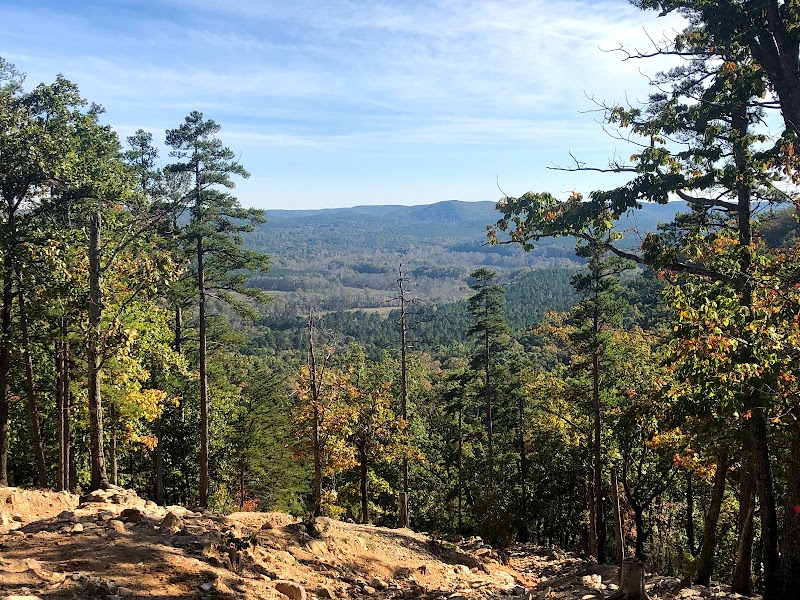
Uwharrie National Forest, located in central North Carolina near Troy, offers rugged landscapes, diverse ecosystems, and a range of recreational activities. This forest spans over 50,000 acres and is known for its scenic trails, off-road vehicle areas, and abundant wildlife. Whether you're hiking, camping, or navigating the backcountry, Uwharrie provides a unique outdoor experience.
Adventure Guide to Exploring Uwharrie National Forest
Dutchman's Creek Trail
- Location: Access from the Wood Run Trailhead, approximately 10 miles west of Troy.
- Why Visit: A challenging 12-mile backcountry trek offering diverse terrain, including creek crossings, rocky inclines, and breathtaking views of the Uwharrie Mountains.
- Key Features: Well-marked paths, a mix of hardwood forests, and connections to the Uwharrie Trail. Great for experienced hikers.
- Local Insights: This trail follows historic gold mining routes from the 1800s, where prospectors sought fortune.
Badin Lake Recreation Area
- Location: Off NC-109, about 15 minutes north of Troy.
- Why Visit: Ideal for both relaxation and adventure with scenic lakefront views. Offers hiking, fishing, and swimming options.
- Key Features: Campgrounds, picnic areas, and boat ramps.
- Local Insights: The lake was formed as part of a hydroelectric project in the early 1900s and remains a prime fishing spot for largemouth bass and crappie.
Uwharrie OHV Trail System
- Location: Off NC-24/27, with multiple access points.
- Why Visit: A network of off-highway vehicle (OHV) routes catering to ATVs, dirt bikes, and 4x4 enthusiasts.
- Key Features: Over 20 miles of rocky, twisting trails requiring skill and proper equipment. Permits required.
- Local Insights: Originally created for timber road access, now a top destination for off-roaders in North Carolina.
Visitor Tips
- Best Time to Visit: Spring and fall offer mild temperatures and peak foliage. Summer can be hot, while winter may bring icy conditions.
- What to Bring:
- Sturdy hiking boots for rough terrain.
- Plenty of water (no reliable water sources on longer trails).
- Bug spray and sun protection.
- Driving Directions: From Troy, take NC-109 north for about 5 miles to reach key trailheads.
Adventure Map
Reviews
Scott “FloatNcarve” Haaland6 months ago
Great place to get unplugged and offl grid for a while if you’re into exploring in the woods on ATV, jeep, or horseback. Also some boat launch, hiking and mountain bike trails and great primitive camp sites. Actually has a little bit of everything for all outdoor interests. Shooting range also. Enjoy exploring in the oldest mountains in the state. No shortage of different camping opportunities. Some dirt access roads can be rough and dusty depending on the season and weather. I like to visit once a month and try to camp
In the cooler off season.
Jeremiah Mangruma month ago
I'm relatively new to Uwharrie, my 2nd trip camping. I'm quickly learning that this is a real gem of a destination for all things outdoor recreation. Camping, hiking, off road trails, Baden lake, historical significance and much more. I will be returning many times in the future. It's beautiful and offers so much. A 2 hr drive from raleigh, much closer to Charlotte NC this was a great short getaway.
David Mansfield3 months ago
Great place to go camp and enjoy the outdoors. Just don't do what I did and park your camper without filling your fresh water tank first. I didn't notice they don't have fresh water connections at the sites. So, I had to take my trailer back to the dump station to fill it after I'd already backed in. LOL! But, it is a great place to take the family.
Explore More Just By Living Day 2 Day (EMJBLD2D)2 months ago
Very nice mtn biking trails and the hunters were kinda enough to let people bike in the great weather. Thank you!
My friend reached out to me to make sure I was safe. LOL. Uworry Forest. Blessed.
Jasmine Geromiller5 months ago
I went to Badin Lake and did the hike around. Very easy hike around the lake about 5.5 miles. It's called a loop but at the end you actually have to turn around. Some of the white trail signs are hard to see, but you're never more than about 20 meters from the water so you can't really get lost. Bathrooms at location which was great! No sinks or drinking sources though so bring plenty of water. Their were some families there on the weekend and were swimming. Lots of boats in the water. Despite the amount of people, it never felt crowded and was relatively quiet which was impressive. I passed a couple of campgrounds and another lake opposite side, even a disc golf course. Lots of activities to do, very peaceful and family friendly. Highly recommend.