Hike the Domingo Baca Trail to TWA Plane Crash Site in Sandia Mountains
Hike the Domingo Baca Trail to TWA Plane Crash Site in Sandia Mountains
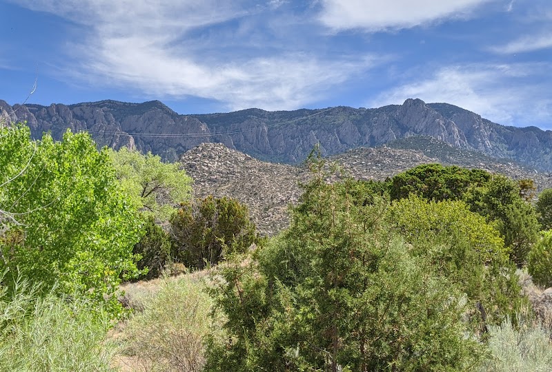
The Domingo Baca Trail leads to one of the most historic and challenging hikes in the Sandia Mountains—the site of the 1955 TWA Flight 260 crash. The trail offers stunning scenery, rugged terrain, and a somber yet fascinating glimpse into history. This journey is ideal for those with experience hiking in rocky and steep conditions who are looking for a rewarding and meaningful adventure.
Adventure Guide to Hike the Domingo Baca Trail to TWA Plane Crash Site
Starting Point and Trail Details
- Trailhead: Access the Domingo Baca Trail from the Ellena Gallegos Open Space, located at 7100 Tramway Blvd NE, Albuquerque, NM.
- Distance & Difficulty: Approximately 7 miles round trip, rated moderate to strenuous due to steep elevation gains and rocky terrain.
- Key Features: The trail takes you through canyons, past boulder fields, and ultimately to the crash site, located at 8,600 feet elevation.
What Makes This Hike Unique
- Historical Significance: The crash of TWA Flight 260 occurred in February 1955, and hikers can still see remnants of the aircraft wreckage.
- Diverse Terrain: The trail passes through shaded forests, rocky washes, and steep inclines, making for a dynamic hiking experience.
- Wildlife and Scenery: Deer, black bears, and coyotes inhabit the area. Expect panoramic views of Albuquerque and the surrounding desert landscape.
Local Insights
- Remnants of the plane have been left undisturbed as a historical site. Out of respect, hikers are advised not to take or disturb any debris.
- The site has an eerie yet reflective atmosphere, often drawing outdoor enthusiasts and history buffs.
Visitor Tips
- Best time to visit: Late spring and early fall offer the best weather conditions with less extreme heat.
- What to bring:
- Hiking boots with strong ankle support.
- Plenty of water (at least 2 liters per person).
- Navigation tools (GPS or a detailed map).
- Directions: From Albuquerque, take Tramway Blvd to Simms Park Road and reach the parking area in about 25 minutes.
Reviews
Robert Wesley4 years ago
A challenging trail when ice and snow are present. Prepare for a temperature change as you head up towards the end of this trail. There are opportunities to take a wrong turn that will take you out of the way if the plane crash is your goal.
Chris R.5 years ago
AKA TWA Crash Site trail: this is a fantastic local hike. Note: IT IS POSSIBLE TO SUMMIT THE MOUNTAIN FROM THIS TRAIL. Once you get into Domingo Baca Canyon, the trail diverges and converges multiple times. Signage isn't always clear, so it's easy to end up a ravine north or south of the one to the crash site. Expect 2- 2 1/2 hours average for reaching the memorial plaque.
The last third of a mile to the crash site becomes slightly more difficult. If you keep to the right (south) trail splits, you will eventually come upon a sizable boulder. It's not overwhelming, but it does require respect. Beyond the main portion of wreckage, the trail continues up the ravine approximately 1/4 mile. Stay to the right (south) of the ravine and you will be next to a very tall rock formation.
The route beyond the wreckage is very clear in the terrain view on Google Maps/ Earth. It's a steep scramble all the way up, summiting to south of the Kawanis Shelter, and to the north of the Tram. Look for the wide, vegetation-covered canyon that gradually narrows as it proceeds upslope to the north.
Eventually, you will find a deer trail that hugs the South rim of the canyon. Although this deer trail goes nearly to the summit, it is extremely steep. After it ends, the dense vegetation gives way to a lush field of grasses and Aspen. Here, you will be approximately 500 meters from the summit, but on your hands and knees most of the time; In part due to the grade of the slope, and because it's easier to grab onto trees and grass clumps for holds.
After about 4 hours, you'll intersect La Luz trail. From there, it's approximately 200 meters to the true summit. It took me 4 hours 44 minutes to summit, but I strayed off course to do some bouldering. That added an additional hour to my summit.
I strongly suggest long sleeves, as thorns are unavoidable. Summiting this way is not easy, but the satisfaction is absolutely worth it.
Muhamed Abdel-Hack4 years ago
Great hike. There is snow in the canyon during the winter but it's a beautiful trek.
Steve Hartig2 years ago
Great trail up along the canyon to the plane wreck which is a very somber sight. The trail is hard to follow at various spots and it is a good idea to have a good map or use something like the Alltrails app to keep on the trail. It is a hard trail so be prepared for a long hike up to the plane
Steph Jose5 years ago
This trail is very difficult and we actually missed the turn to the right (which has an orange TW spray painted on a rock) and ended up just going up the river bed and gorge all the way past the tram lines. We essentially missed the wreckage completely because we were on the wrong side. We went through shrub, thorns and numerous huge rock faces before finally turning back. We realized where we missed the turn on the way down. Guess we will have to go again!