Hiking the Alum Cove Natural Bridge Trail in Ozark National Forest, Arkansas
Hiking the Alum Cove Natural Bridge Trail in Ozark National Forest, Arkansas
Introductory Overview
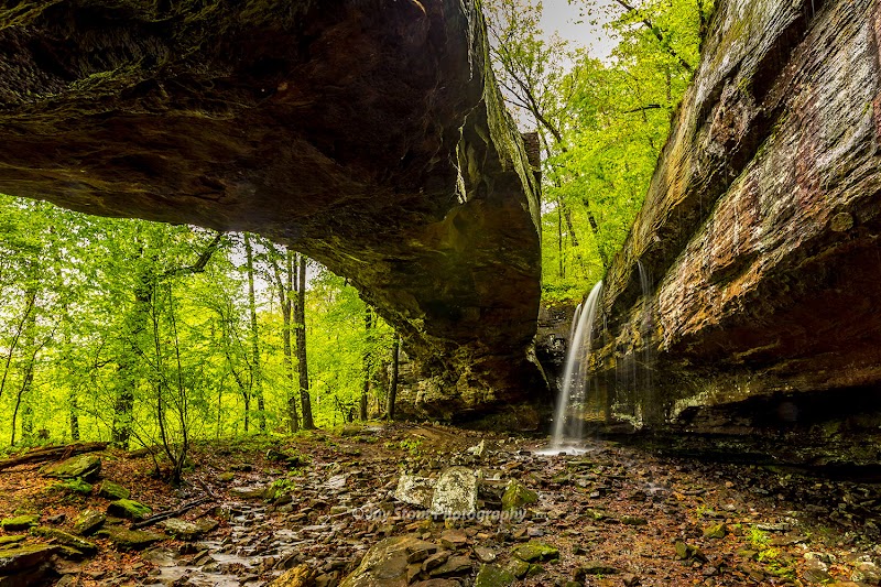
Located within the Ozark National Forest, the Alum Cove Natural Bridge Trail is a must-visit for nature enthusiasts and hikers seeking breathtaking geological wonders. This moderately easy, 1.1-mile trail features the Alum Cove Natural Bridge, a remarkable sandstone formation towering 50 feet above the forest floor and stretching 130 feet across. This arch is not only a striking natural landmark but also a historically significant site, as it was once used by early settlers and Native Americans as a crossing and shelter. Beyond its natural beauty, the trail offers peaceful walks through lush forested areas, making it one of the standout hiking experiences in the region.
### Adventure Guide to Hiking the Alum Cove Natural Bridge Trail
-
The Alum Cove Natural Bridge
- Key Feature: The main attraction, this enormous sandstone bridge, highlights millions of years of erosion and weathering that shaped it. Visitors can walk beneath and across the bridge to fully appreciate its size and structure. The vantage points from underneath provide incredible photo opportunities, especially in the early morning or late afternoon when sunlight accentuates its textures.
- Local Note: Snap pictures quickly after rain for vibrant moss and lichen colors on the bridge.
-
The Trail Itself
- Details: This 1.1-mile loop trail is well-marked and relatively easy for hikers of varying skill levels. Although short, the elevation changes can be moderate in sections, particularly leading into the valley below the bridge. Along the way, you’ll encounter serene forested areas and interesting rock outcrops that add to the trail's charm.
-
Hidden Features Along the Trail
- Points of Interest: Keep an eye out for small caves, rock shelters, and unique geological formations scattered throughout the trail. Pair these discoveries with the natural bridge for a fuller appreciation of the region’s geological history.
- Unique Insight: Many of these shelters were used by Indigenous peoples as seasonal habitation sites, leaving a rich history embedded in the landscape.
Visitor Tips
- Best Time to Visit: Spring and fall are ideal for cooler temperatures and vibrant foliage.
- What to Bring: Comfortable hiking shoes, water, and a camera.
- Driving Directions: About a 45-minute drive south from Jasper, Arkansas, via AR-7 N and AR-16 W.
Adventure Map
Reviews