The Pohono Trail, spanning approximately 13 miles one way, is a challenging yet rewarding hike located along Glacier Point Road in Yosemite National Park. This trail provides hikers with some of the most sweeping views of Yosemite Valley, along with access to famous lookouts like Tunnel View, Dewey Point, and Taft Point. The trail is perfect for those seeking a mix of solitude, breathtaking scenery, and immersion in Yosemite’s natural beauty. It’s an essential hike for anyone visiting the area with a passion for adventure and photography.
Adventure Guide to Hiking the Pohono Trail
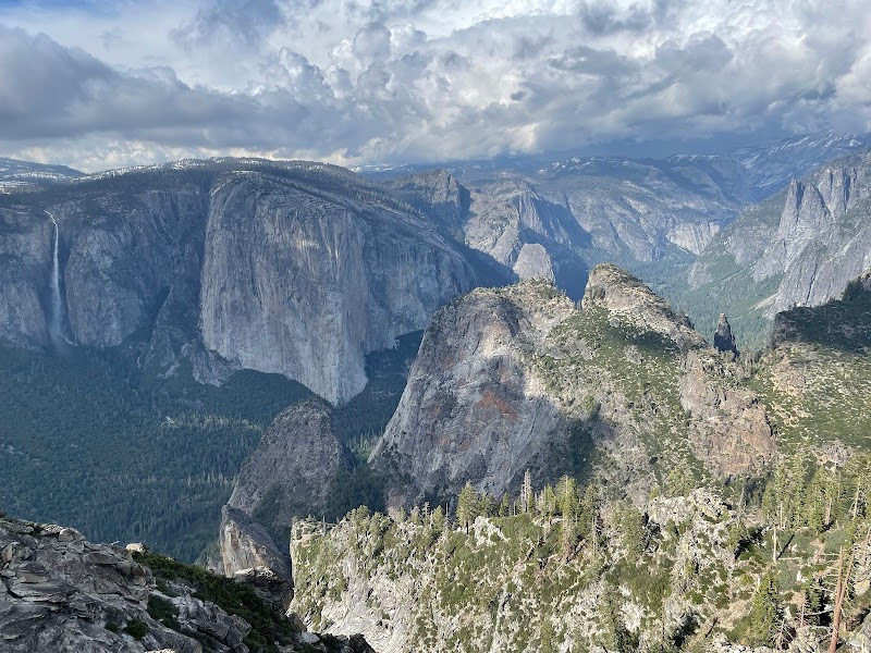
Glacier Point Trailhead: The trail begins (or ends) at Glacier Point, offering a panoramic view of landmarks such as Half Dome, Vernal and Nevada Falls, and the Yosemite Valley floor. Glacier Point’s unique location makes it an ideal starting point to tackle the Pohono Trail. Its high elevation sets the stage for breathtaking vistas right from the beginning.
Dewey Point: Found roughly mid-hike, Dewey Point is one of the most captivating viewpoints on the Pohono Trail. Here, hikers are rewarded with uninterrupted vistas of El Capitan and other granite formations. This serene spot provides a great place to rest and absorb the grandeur of the valley.
Tunnel View Exit: The Pohono Trail’s western endpoint is near Yosemite’s famous Tunnel View. By hiking in this direction, you’ll descend noticeably in elevation. Tunnel View offers an iconic snapshot of Yosemite Valley, with striking views of El Capitan, Bridalveil Fall, and Half Dome.
Visitor Tips
Best Time to Hike: Late spring through early fall is optimal. Snow can linger at higher elevations, particularly in spring, so check trail conditions beforehand.
What to Bring: Pack plenty of water, sturdy trail shoes, snacks, sunscreen, and layers, as temperatures often fluctuate.
How to Get There: From Yosemite Valley, drive along Wawona Road to Glacier Point Road. It’s about a one-hour drive to Glacier Point. Alternatively, shuttle services may be available seasonally.
Local Insights
The name “Pohono” comes from the Miwok word for "spirit of the waterfall,” reflecting its deep Native American connections.
Adventure Map
Reviews
Shourjya Dasgupta6 years ago
I didn't do the whole trail. I was out there to get a different view of the valley, but i couldn't find a better one after walking for 20 minutes. Moreover the trail was icy and my shoes were slipping too often. Had to come back.
James Hill Real Estatea year ago
Backpacked this trail west to east on 5/30 - 6/2 from tunnel view to Bridal Veil Creek. Original plan was to get to Glacier Point but navigating the snow created more time than I had anticipated. The trail starts on the south side of of tunnel view where you will see the trail marker and granite steps. I took the valley shuttle to El Cap meadows and hitchhiked to tunnel view, about 3.3 miles. The trail is all uphill with very few flat areas. There was 80-90% snow covered after about a a mile in making for difficult navigation at times and many postholes to try to avoid. I started on the trail at 1:00 and camped at inspiration point that night at about 5:00pm. Weather was between 40-58º, cloudy with intermittent sunshine. Perfect weather. Filtering water was not an issue as the snowpack provided plenty of runoff. If this trail is done in late summer water would be an issue. Second day hiked past Crocker Point to Dewey Point and camped there for the night. Crocker and Dewey Point are indescribable as far as the views. You really have to see it in person to appreciate the beauty. On the third day I hiked to Bridal Veil Creek and camped about 100 ft from the creek. Got a little chilly that night but the water producing an excellent tranquil environment for sleeping. Once past Dewey Point I didn't see another person. On the way to Dewey Point I only saw 4 people total in 4 days. On day for I hiked back down to Bridal Veil Falls parking lot past Artist point. Artist Point is a must see. Spectacular view of the valley, El Cap and Ribbon Falls. It is off the beaten path and I did not seen another person until I reached the Bridal Veil Falls parking lot. By the time I reached the shuttle the walk down was 10.5 miles. I took me about 10 hours from top to bottom with several creeks to navigate across that were no joke. I almost had to turn around in between Artist Point and Bridal Veil Falls parking lot. The hike up in a constant slog. I was carrying a 35 pound pack and it added to the work. This hike can be done in a day under the right conditions with only a camel back and minimal supplies. Highly recommend doing this during the late spring when water is more available and the weather is good.