Hiking to Greyrock Mountain at Greyrock Trailhead (Poudre Canyon)
Hiking to Greyrock Mountain is a must-do adventure for outdoor enthusiasts visiting Poudre Canyon near Fort Collins, Colorado. This iconic hike is renowned for its challenging yet rewarding trails that showcase breathtaking views and diverse ecosystems. Located within Roosevelt National Forest, Greyrock Mountain offers a unique hiking experience combining rugged terrain, scenic beauty, and a summit that delivers panoramic vistas of the surrounding landscape.
Adventure Guide to Hiking to Greyrock Mountain
Trail Overview: The hike begins at the well-maintained Greyrock Trailhead, accessible via Highway 14 in Poudre Canyon. Hikers have two main trail options: the Greyrock Meadows Trail (Trail #947) and the Greyrock Summit Trail (Trail #946). The loop combining these trails totals approximately 7.4 miles with 2,000 feet of elevation gain. The terrain includes rocky switchbacks, wildflower-filled meadows, and forested sections, offering variety throughout your journey.
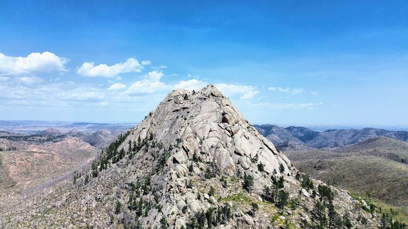
The Summit: The final stretch to Greyrock Mountain's summit is a steep scramble over rocks, making it both challenging and thrilling. Once you reach the top, you're rewarded with stunning 360-degree views, including Poudre Canyon, the Front Range, and even distant glimpses of the Mummy Range on clear days. The summit's unique rock formations also provide an ideal spot for a lunch break or photo session.
Wildlife and Nature: The trail is home to diverse wildlife such as mule deer, elk, and occasional black bears. In the summer, the meadows are vibrant with blooming wildflowers, while autumn brings golden hues from aspen groves. The area is also rich in history, with Greyrock Mountain serving as a landmark for Indigenous peoples and early settlers.
Visitor Tips
Best Time to Visit: Late spring through early fall offers the best conditions. Winter hikes are possible but require proper gear due to icy trails and snow accumulation.
What to Bring: Wear sturdy, non-slip hiking boots, pack plenty of water (at least 2-3 liters), and bring snacks or lunch for a break at the summit. Sunscreen and layers are essential, as the weather can change quickly.
Driving Directions: From Fort Collins, take Highway 287 to Highway 14 and head west into Poudre Canyon. The trailhead is approximately 23 miles from Fort Collins, with a 35–40-minute drive time.
Adventure Map
Reviews
Noah Adams3 years ago
Probably the best hike near Fort Collins. Amazing views from the top and a scenic hike all around. The meadows trail is significantly longer with less shade but has better views.
Jason Helms4 years ago
Easily one of my favorite hikes and very close to town. This means on the weekends it can get quite busy and you may not have an easy time of finding parking. I’ve done this hike countless times in all seasons and it’s always an enjoyable experience. Do not skip the last bit to get to the very top. It’s well worth it. You can even camp out here but no longer on top of the rock itself. The meadows provides good spots for camping though. There are also a handful of trad routes on the south face and some sport routes a little further east. I can't speak to the sport routes but the trad routes are 2-3 pitches and not terribly difficult. 5.8 I believe for the longest one.
khy8 months ago
Greyrock is a wonderful, moderate hike to take in a variety of natural aromas, unbelievable scenery, and fresh air. The weather was ideal also, a light rain cooled us all off at the most ideal timing on the way back down the mountain. I love the rock formations and bouldering opportunities. It genuinely feels like free climbing at times as you near the summit, but it’s an engaging experience to be physically present yet so disconnected from day to day urban life.
Cole Dwyer2 years ago
Greyrock is my favorite hike in NoCo. It takes about 4 to 5 hours, and it has a variety of views. It’s a great place to escape reality, and also practice for longer hikes. It’s surreal walking through the remains of the forest that burnt down years ago, and it gives you a sense of smallness and an idea of how vast Colorado is.
Michael Windsor4 years ago
This is one of the steepest hikes I've been on near fort collins. It gains 2,300 ft over the 4 mile hike to the peak. Young Gulch Trail, just down the road, gains half that in 5 miles. Having said that, it's also one of the coolest hikes in the area. At the peak, you get a beautiful 360 degree view of the front range and the plains. To get there, you'll need to scramble up some pretty big rocks and find your way along a minimally marked trail. I had a map of the trail on my phone and needed to check it several times to make sure I wasn't lost. The meadow side of the trail (as well as the peak) were very windy, with gusts that felt like they must have been near 50 mph. You should come prepared for changing conditions. I hikes the trail January 2nd and it had just snowed a week ago. The high was in the 40s and the sun was shining so the air was pretty comfortable. But there were several icy spots on the trail so bringing microspikes is useful. The loop trail itself is beautiful and, although still difficult, it's more friendly than going to the peak.